Others
Monday, June 24, 2024
We’re addressing multiple road safety problems:`
- Improving the work safety of road inspectors by reducing time being physically in the middle of the road and reducing multitasking while driving.
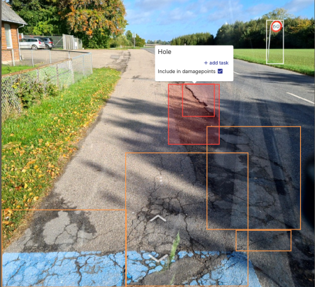
- Improving road safety for cars, motorcycles and bicyclist by reducing potholes and defect road inventory such as faded road signs, damaged bollards, etc.
- Improving road safety for pedestrians by mapping crosswalks with worn-out lane markings as well as pavement uplift that causes people to fall.
Image examples can be found attached
Sunday, June 23, 2024
Zavarovalnica Triglav od leta 2015 ponuja mobilno aplikacijo DRAJV, ki spodbuja in nagrajuje varno vožnjo. Aplikacija z uporabo tehnologij telematike spremlja hitrost vožnje, premike telefona in sile med vožnjo. Aplikacija DRAJV prispeva k varnejši vožnji z nadzorom hitrosti, analiziranjem voznih navad in ozaveščanjem uporabnikov, kar zmanjšuje tveganja za nastanek prometnih nesreč, ki ostajajo globalen izziv. Glavni vzrok prometnih nesreč v Sloveniji je še vedno neprilagojena hitrost vožnje, aplikacija DRAJV pa tako s spodbujanjem vožnje s primerno hitrostjo pozitivno vpliva na prometno varnost, saj so aplikacijo DRAJV na svojih vožnjah uporabili vozniki 8-10 % vseh osebnih vozil v Sloveniji.
En večjih globalnih problemov je tudi uporaba mobilnega telefona med vožnjo, kar povzroča neosredotočenost na dogajanje v prometu in močno povečuje tveganja za nastanek prometne nesreče. Aplikacija DRAJV spremlja in ocenjuje tudi pogostost uporabe telefona med vožnjo in nagrajuje voznike, ki telefona med vožnjo ne uporabljajo.
Aplikacija DRAJV obravnava glavne izzive varnosti na cestah, kot so prekoračitve hitrosti, uporaba telefona, sunkovita pospeševanja, zaviranja in vožnje v ovinek. Aplikacija je posebej prilagojena tudi za voznike motornih koles in tako spodbuja varno vožnjo motoristov, ki so med najbolj ranljivimi udeleženci v prometu.
Na podlagi anonimiziranih podatkov voženj uporabnikov, ki so skupno prevozili več kot 1,6 milijarde kilometrov, smo izdelali tudi interaktivno spletno orodje »DRAJV zemljevid«, ki identificira nevarne cestne odseke v Sloveniji z vidika hitrosti vožnje in drugih parametrov, ki jih spremlja aplikacija DRAJV.
Sunday, June 23, 2024
The Mobilidata program addresses the lack of centralized, timely and qualitative real time traffic warnings in the G2B2C ecosystem.
To fulfil the need of road users to receive and be able to cooperate with (return) real time traffic warnings, Mobilidata implemented for the entire Flanders- region and on the entire public road network the European defined C-ROADS standardized Cooperation model of C-ITS or Cooperative ITS. In Mobilidata 31 different use cases are addressed – see overview of all use cases under 7.2 -images
Mobilidata is the Flanders hub where real time road safety related information comes together from these sources:
• Governmental regional and local level: e.g. roadside infrastructure like traffic controllers, variable message signs,
• Private/corporate level: e.g. Directive 2010/40/EU, EU specified SRTI (safety related traffic information) - vehicle sensor based real time warnings.
• Road user ‘community’ based: Events reported, and event feedback generated by road users.
Each of these 3 source information systems has its strengths and weaknesses, offering a neutral environment where they can be combined and distributed to all interested in a non-commercial setting is possible in a road-safety promoting context.
Road safety information in Mobilidata can be clustered in 3 subgroups per topic in the 29 on-street use case list + an extra subgroup of 2 off-street policy related use cases:
• Road regulation & policies
• Warnings / dangerous situations
• Connected infrastructure / traffic lights
Saturday, June 22, 2024
Governments and administration need to do more to improve road safety. But, the statistics for road traffic accidents are still shocking. Around 90% of all road accidents are caused by human error. That means every year, about a million people die because of other people's mistakes, carelessness, or irresponsibility. So it makes you wonder, are we doing good enough for road safety? Safe Driving, aims to help and informing whole road users about every single issue in Road Traffic from A to Z.
Thursday, June 20, 2024
The safety and interaction of cyclists during infrastructure conservation and repair works are significantly impacted by changes made, potentially leading to new conflicts between cyclist traffic and vehicles.
The BIKEFLOW project's objective is to enhance cyclist safety in critical areas identified within modified sections during ongoing conservation efforts. By employing video analytics and Artificial Intelligence, we can examine the movements and potential interactions of cyclists and vehicles. This technology utilizes video analysis to forecast safety levels before incidents happen, enabling the identification of vehicles, routes, and speeds, with the capability to present data in real-time or upon request. In light of these analyses, permanent cameras have been installed at the junction of N-110 and N-502 to conduct surrogate safety assessments. This involves applying various configurations to the route to analyze the behavior of road users (both vehicles and cyclists) and to train an AI model that determines the most suitable layout configuration. The findings are then applied to adjust signage, lower speed limits, establish protected lanes at critical junctures, or modify paths as necessary.
Wednesday, June 19, 2024
Asociatia Drum Sigur analyzed and researched the following design errors:
- incorrect use of signs for yielding priority in intersections (Give Way and Stop signs) (error found in most countries of the world)
- the formulas used to calculate the length of acceleration/deceleration lanes at road junctions are incorrect (they do not take into account the impact of heavy vehicle traffic, as well as the volume of traffic flows) (error found worldwide)
- the use of staggered pedestrian crossings at traffic lighted intersections has negative effects on pedestrian traffic in most cases. (case analysis for all the staggered pedestrian crossings in Bucharest)
- identification of design and execution errors for T-type intersections, roundabouts, turbo-roundabouts or interchanges in some cities in Romania.
- analyzing some design errors on certain streets in Bucharest and proposing measures to improve road safety and traffic flow.
Monday, June 17, 2024
Our experience shows that most road accidents are caused by human error. Various analyses carried out by ALSA show that most road accidents are caused by inappropriate driver behaviour.
In order to manage road safety proactively, it is necessary to have a detailed and rigorous knowledge of the performance and behaviour of each driver in order to know their skills and behaviours, as well as to track their evolution over time.
To this end, ALSA has invested in technology in more than 3,700 vehicles in Spain that allows us to measure speeding, monitor various parameters that reflect driving style and detect various driver behaviours using innovative smart camera technology.
These smart cameras are based on "machine vision” and "artificial intelligence" (MV+IA) systems, which allow us to detect 40 types of driver behaviour and are particularly noteworthy for their innovation.
The data provided by the aforementioned technologies is used to calculate the risk profile of each driver. ALSA defines personalised actions for each driver: training, assignment to certain vehicles and routes, greater follow-up and monitoring, etc.
In addition, each driver has access to the data available on their own performance through an internal app (called "MiAlsa"). In this way, drivers can consult information on their own performance (consumption, driving styles, speeding, incidents, etc.).
Sunday, June 16, 2024
The key objective is to improve the safety of learner drivers and provide a safe driving environment in which learners can practice safe driving skills. In primary research undertaken in 2018, 31% of Advanced Driving Instructors (ADIs) surveyed agreed that the Essential Driver Training programme (EDT) in Ireland did not provide a safe driving environment for learner drivers. Although it is illegal, driving unaccompanied is regularly done by a large percentage of learner drivers. As part of Phase 1 of the Road Safety Strategy (RSS) 2021-2024 a goal has been set to eliminate unaccompanied driving in Ireland by Q4 2024. The Behaviours and Attitudes Survey (2019) found 39% of learner drivers drive unaccompanied. In 2022, 5,929 learner drivers received penalty points for driving unaccompanied.
Ireland has a population of 5.5 million people, on average per year we have 11 fatalities and 45 serious injuries from road collisions with drivers pre-test (2007-2021 data). 80% of fatal collisions involved learner drivers who were driving unsupervised, while 75% of serious injury collisions involved unsupervised learner drivers. We know from research undertaken that collisions involving learner drivers reduce by 80% whilst accompanied. No one should die while learning to drive.
Sunday, June 16, 2024
We are addressing road safety for motorcyclists safety and innovative, pragmatic infrastructure solutions, that are working and can be applied on the roads, mainly for pro-active approach, and as well as active (passive safe).
Friday, June 14, 2024
El desafío es implementar una iniciativa que permite mejorar y poner en práctica acciones que reduzcan los enclaves de concentración de accidentes, recogiendo el propósito de “Avanzar juntos hacia una movilidad segura”, compartiendo y comprometiéndonos a conseguir unos objetivos, desarrollando unas actividades que permite abordar con éxito el problema de la seguridad vial urbana en la Ciudad de Madrid, la segunda Ciudad Europea con mayor población.