Cyclists

5th National Day of Road Safety

On October 21, 2024, Croatia celebrated the 5th National Day of Road Safety at Ban Josip Jelačić Square in Zagreb. The event, organized by the Ministry of the Interior, aimed to educate the public on road safety and especially motorcycle safety amid rising accident rates. Key participants included Deputy Prime Minister Davor Božinović, police chief Nikola Milina, the Croatian Automobile Club and various institutions involved in the National Road Safety Plan.

HAK participates in the National Cycling Conference

The National Cycling Conference took place in Osijek from October 9-11, 2024, as a significant initiative by the Croatian Ministry of Sea, Traffic, and Infrastructure. Launched in 2022 as part of the EU's Danube Cycle Plans, the conference provided a platform for stakeholders to collaborate on enhancing cycling infrastructure and promoting cyclotourism. During the event, it was highlighted that cycling participation in Croatia stood at only 6%, which was significantly lower than in many European countries.

Tuesday, June 25, 2024
We continually see in the media news of accidents involving cyclists.
During recent years, the use of bicycles has increased significantly and according to forecasts, this growth will continue in the coming years since many European policies are aimed at promoting the use of this vehicle as an alternative means of transport.
This increase in bicycle use is accompanied by an increase in accidents, which has caused great concern in society since this group is the only one in which the number of deaths has increased since 2010.
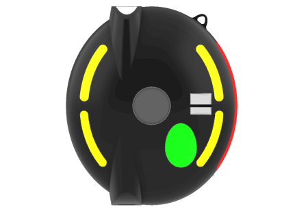
For this reason, SOSTRAFFIC BIKE was born as a safety element for cyclists, helping them, on the one hand, to inform other drivers of their position on the road, both visually through flashes of light and telematically via connectivity to the DGT 3.0 platform, and on the other hand, provide the contact with the best possible information for the location of the injured person and reduce the response time in locating them, which will increase the survival rate.
.
On the other hand, the maps used by SOSTRAFFIC include roads and mountain trails, so in the event of a fall, the entire route taken by the cyclist will be recorded from the start and will allow for quick geolocation. This is important since in the event of a fall in the mountains, this information can be key to accessing the injured person quickly.


The SOSTRAFFIC BIKE project It is an innovative product connected to the DGT 3.0 cloud.
This device has a light to visually warn drivers of the cyclist's presence, a camera with a microphone to record everything that happens during the journey, an App linked to the device and a connection to the DGT 3.0 cloud.
When the cyclist starts the route, it sends a message to these contacts with a link where they can check his position and the route taken at a given moment. At the end of the route they receive an end of route message.
During the route, it sends the cyclist's position in real time to the DGT 3.0 cloud so that navigators, cars or any other device connected to this cloud can receive the information and alert the driver of the presence of a cyclist on the route, even if he is in a curve or area not visible to the driver.
In the event of a fall, a countdown starts which, if not deactivated, sends a message to the contacts indicating the location of the accident and the route taken by the cyclist from the beginning of the route to the fall on a 3D map (this is important especially in falls on mountain trails) and a video with sound of what happened just before, during and after the fall.
The video will allow us to identify the reason for the accident, even use it as evidence in case the vehicle flees and the images of the accident will be recorded on the SOSTRAFFIC server
If the cyclist enters an area without telephone coverage and the time that passes is greater than the preset in the App, the device automatically sends a notice with the route taken, time without coverage and possible location of the cyclist.

Monday, June 24, 2024
We’re addressing multiple road safety problems:`

- Improving the work safety of road inspectors by reducing time being physically in the middle of the road and reducing multitasking while driving.
- Improving road safety for cars, motorcycles and bicyclist by reducing potholes and defect road inventory such as faded road signs, damaged bollards, etc.
- Improving road safety for pedestrians by mapping crosswalks with worn-out lane markings as well as pavement uplift that causes people to fall.

Image examples can be found attached
Sunday, June 23, 2024
The Mobilidata program addresses the lack of centralized, timely and qualitative real time traffic warnings in the G2B2C ecosystem.

To fulfil the need of road users to receive and be able to cooperate with (return) real time traffic warnings, Mobilidata implemented for the entire Flanders- region and on the entire public road network the European defined C-ROADS standardized Cooperation model of C-ITS or Cooperative ITS. In Mobilidata 31 different use cases are addressed – see overview of all use cases under 7.2 -images

Mobilidata is the Flanders hub where real time road safety related information comes together from these sources:
• Governmental regional and local level: e.g. roadside infrastructure like traffic controllers, variable message signs,
• Private/corporate level: e.g. Directive 2010/40/EU, EU specified SRTI (safety related traffic information) - vehicle sensor based real time warnings.
• Road user ‘community’ based: Events reported, and event feedback generated by road users.

Each of these 3 source information systems has its strengths and weaknesses, offering a neutral environment where they can be combined and distributed to all interested in a non-commercial setting is possible in a road-safety promoting context.

Road safety information in Mobilidata can be clustered in 3 subgroups per topic in the 29 on-street use case list + an extra subgroup of 2 off-street policy related use cases:
• Road regulation & policies
• Warnings / dangerous situations
• Connected infrastructure / traffic lights
Saturday, June 22, 2024
Governments and administration need to do more to improve road safety. But, the statistics for road traffic accidents are still shocking. Around 90% of all road accidents are caused by human error. That means every year, about a million people die because of other people's mistakes, carelessness, or irresponsibility. So it makes you wonder, are we doing good enough for road safety? Safe Driving, aims to help and informing whole road users about every single issue in Road Traffic from A to Z.
Thursday, June 20, 2024
The safety and interaction of cyclists during infrastructure conservation and repair works are significantly impacted by changes made, potentially leading to new conflicts between cyclist traffic and vehicles.
The BIKEFLOW project's objective is to enhance cyclist safety in critical areas identified within modified sections during ongoing conservation efforts. By employing video analytics and Artificial Intelligence, we can examine the movements and potential interactions of cyclists and vehicles. This technology utilizes video analysis to forecast safety levels before incidents happen, enabling the identification of vehicles, routes, and speeds, with the capability to present data in real-time or upon request. In light of these analyses, permanent cameras have been installed at the junction of N-110 and N-502 to conduct surrogate safety assessments. This involves applying various configurations to the route to analyze the behavior of road users (both vehicles and cyclists) and to train an AI model that determines the most suitable layout configuration. The findings are then applied to adjust signage, lower speed limits, establish protected lanes at critical junctures, or modify paths as necessary.
Wednesday, June 19, 2024
Asociatia Drum Sigur analyzed and researched the following design errors:
- incorrect use of signs for yielding priority in intersections (Give Way and Stop signs) (error found in most countries of the world)
- the formulas used to calculate the length of acceleration/deceleration lanes at road junctions are incorrect (they do not take into account the impact of heavy vehicle traffic, as well as the volume of traffic flows) (error found worldwide)
- the use of staggered pedestrian crossings at traffic lighted intersections has negative effects on pedestrian traffic in most cases. (case analysis for all the staggered pedestrian crossings in Bucharest)
- identification of design and execution errors for T-type intersections, roundabouts, turbo-roundabouts or interchanges in some cities in Romania.
- analyzing some design errors on certain streets in Bucharest and proposing measures to improve road safety and traffic flow.
Monday, June 17, 2024
From July 2024, stricter EU regulations (GSR II) will come into force for all newly registered trucks and buses. Most of these also apply to city buses. An important exception in GSR II is the emergency braking assistance system, which is not mandatory for buses with unprotected standing and seated passengers. For this type of city bus, ZF has developed a brake assistance system that reduces the consequences of a possible collision. It contains a braking cascade which starts with a first braking pulse which enables sufficient reaction time for standing passengers in order to prepare for the actual braking maneuver, for example by holding and/or a compensating step. The deceleration is then raised to a conservatively selected value which is still controllable for standing passengers and at the same time represents a satisfactory balance with the desired reduction in the vehicle speed and the reduction in the severity of the collision. The Collision Mitigation System (CMS) protects both passengers and vulnerable road users and enables a safer urban public transport.
Monday, June 17, 2024
Our experience shows that most road accidents are caused by human error. Various analyses carried out by ALSA show that most road accidents are caused by inappropriate driver behaviour.
In order to manage road safety proactively, it is necessary to have a detailed and rigorous knowledge of the performance and behaviour of each driver in order to know their skills and behaviours, as well as to track their evolution over time.
To this end, ALSA has invested in technology in more than 3,700 vehicles in Spain that allows us to measure speeding, monitor various parameters that reflect driving style and detect various driver behaviours using innovative smart camera technology.
These smart cameras are based on "machine vision” and "artificial intelligence" (MV+IA) systems, which allow us to detect 40 types of driver behaviour and are particularly noteworthy for their innovation.
The data provided by the aforementioned technologies is used to calculate the risk profile of each driver. ALSA defines personalised actions for each driver: training, assignment to certain vehicles and routes, greater follow-up and monitoring, etc.
In addition, each driver has access to the data available on their own performance through an internal app (called "MiAlsa"). In this way, drivers can consult information on their own performance (consumption, driving styles, speeding, incidents, etc.).
Subscribe to Cyclists